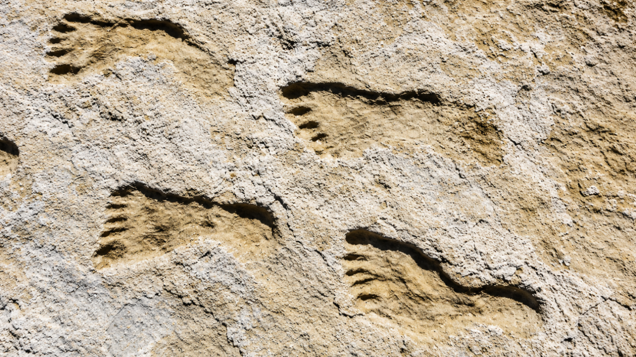
The long-standing consensus regarding the peopling of the Americas dictates that human entry occurred no earlier than 13,000 to 16,000 calibrated years before present (cal yr BP), a timeline bounded by the melting of the Laurentide and Cordilleran ice sheets and defined archaeologically by the Clovis lithic horizon. Empirical findings at White Sands National Park, New Mexico, invalidate this model by establishing human presence between 21,000 and 23,000 cal yr BP. This temporal displacement of approximately 8,000 years proves that populations occupied the interior of North America during the Last Glacial Maximum (LGM), a period when physical ice barriers ostensibly sealed the primary northern migratory corridors.
To validate a chronological anomaly of this magnitude, the underlying geochronological data must withstand rigorous error-bound analysis and reservoir-effect discounting. The breakdown of the White Sands data demonstrates how multi-proxy chronostratigraphy resolved a profound archaeological contradiction.
The Tri-Proxy Geochronological Framework
The primary barrier to accepting the White Sands footprints was the potential for systemic dating bias. The initial 2021 chronological model relied on the radiocarbon ($^{14}\text{C}$) dating of seeds from the aquatic macrophyte Ruppia cirrhosa embedded within the track-bearing layers. Critics correctly identified a potential carbon-sink vulnerability: aquatic plants frequently ingest dissolved inorganic carbon (DIC) from localized groundwater rather than atmospheric carbon dioxide. This reservoir effect can introduce an artificial aging bias, skewing results by millennia.
To isolate and eliminate this error vector, subsequent investigations implemented a tri-proxy validation strategy, utilizing independent physical mechanisms to cross-reference the temporal horizons.
1. Terrestrial Pollen $^{14}\text{C}$ Isolation
Researchers extracted and concentrated approximately 75,000 terrestrial pollen grains per sample from the exact stratigraphic units containing the Ruppia seeds. Unlike aquatic plants, terrestrial flora fixes atmospheric carbon directly, bypassing the groundwater DIC bottleneck. The resulting $^{14}\text{C}$ ages from the atmospheric-linked pollen matched the seed dates with statistical precision, falling squarely within the 21,000–23,000 cal yr BP range.
2. Optically Stimulated Luminescence (OSL)
To eliminate radiocarbon anomalies entirely, scientists applied OSL dating to quartz grains sampled from the footprint-bearing sediment matrix. OSL measures the cumulative ionizing radiation dose trapped in the crystalline lattice of mineral grains since their last exposure to sunlight.
The OSL age equation calculates the time ($T$) elapsed since burial:
$$T = \frac{D_e}{\dot{D}}$$
Where $D_e$ represents the equivalent dose (Gy) accumulated from ambient environmental radiation, and $\dot{D}$ represents the environmental dose rate ($\text{Gy/ka}$). The OSL analysis yielded a minimum burial age of ~21,500 years, providing a non-radiometric boundary that corroborated the $^{14}\text{C}$ data.
3. Stratigraphic Correlation Matrix
In 2025, independent laboratories executed secondary radiocarbon testing on macro-organic matter and mud matrices across broader profiles of the paleo-lake Otero basin. The results yielded a consistent chronostratigraphic sequence spanning from >23,600 to 17,000 cal yr BP.
| Dating Proxy | Carbon/Energy Source | Target Analyte | Confirmed Age Range (cal yr BP) |
|---|---|---|---|
| Aquatic Macrophyte $^{14}\text{C}$ | Groundwater DIC / Atmospheric | Ruppia cirrhosa seeds | 21,130 (±250) to 22,860 (±320) |
| Terrestrial Pollen $^{14}\text{C}$ | Direct Atmospheric $\text{CO}_2$ | Conifer / Angiosperm pollen | 21,000 to 23,000 |
| Sedimentary OSL | Ionizing Radiation / Solar Bleaching | Quartz crystalline lattice | $\ge$ 21,500 |
| Regional Stratigraphy (2025) | Mixed Organic Sediment / Mud Bed | Paleo-lake Otero matrix | 17,000 to 23,600 |
Depositional Dynamics and Taphonomic Preservation
The physical survival of hundreds of thousands of individual tracks across multiple horizons requires highly specific sedimentological conditions. The White Sands footprints are not isolated impressions; they exist within a 2,000-year compressed sedimentary profile on the margins of Lake Otero, a sprawling Pleistocene water body that filled the Tularosa Basin.
The taphonomic sequence operates via a cyclic depositional mechanism:
- The Substrate Phase: Human and megafauna movement occurred on damp, cohesive gypsum-rich muds along the shallow margins of the lake. The high moisture content allowed for sharp anatomical definition, recording heel strikes, medial longitudinal arches, and digital impressions.
- The Mineralization Phase: Soluble salts and fine-grained gypsum crystals precipitated rapidly as micro-water levels fluctuated, capping the impressions without eroding the fine edges.
- The Sealing Phase: Periodic, low-energy lacustrine transgressions deposited thin layers of olive-gray clay and silt over the footprint horizons. These low-oxygen clay caps effectively sealed the impressions from subaerial erosion and bioturbation, preserving them across a multi-tiered stratigraphic stack.
Anthropological Demographics and Behavioral Mechanics
The ichnological record at White Sands offers quantifiable insights into the social structure and spatial economy of LGM populations, distinct from the stone tool assemblages that dominate the Clovis record. Morphometric analysis of track length and stride width permits the classification of the track-makers by age and stature.
The biometric data indicates a highly skewed demographic distribution. The vast majority of the footprints belong to children and teenagers, with adult tracks occurring in low frequencies. In one specific trackway, a clear behavioral sequence is recorded over a continuous distance of roughly one mile:
- Mass-Load Kinematics: An individual—identified by foot dimensions as either a young adult female or a subadult male—traveled across the muddy playa while carrying a juvenile. The additional weight caused asymmetric footprint deepening and lateral sediment displacement (slippage) under the load-bearing foot.
- Intermittent Locomotion: The trackway shows discrete zones where the juvenile was temporarily placed on the ground, leaving small, distinct footprints alongside the larger tracks, before being lifted back up.
- Megafaunal Interactivity: The outbound and return legs of this journey are bisected by the tracks of a Columbian mammoth (Mammuthus columbi) and a giant ground sloth (Paramylodon harlani). The mammoth crossed the human path linearly, exhibiting zero behavioral deviation. The ground sloth, conversely, altered its gait to a circular pattern, rising onto its hind limbs—a clear indicator of sensory detection and predator-avoidance behavior.
This demographic signature suggests a structured division of labor. The high concentration of juvenile tracks clustered around the lacustrine margin indicates that resource extraction, foraging, or domestic processing tasks were systematically delegated to younger cohorts, while adults operated in alternative, high-skill zones farther afield.
The Structural Breakdown of Existing Migration Models
The confirmation of an active human population in New Mexico at 23,000 cal yr BP creates a profound geographic and logistical paradox for traditional North American migration vectors.
During the peak of the LGM (26,500 to 19,000 cal yr BP), the coalesced Laurentide and Cordilleran ice sheets formed an unnavigable terrestrial wall extending from the Atlantic to the Pacific across modern Canada. The interior "Ice-Free Corridor" did not open until approximately 14,000 to 15,000 cal yr BP. Concurrently, the Pacific Coastal Route was heavily glaciated, presenting severe maritime hurdles to southward movement.
Because humans were already situated south of the glaciated zone by 23,000 cal yr BP, migration must have occurred via one of two structural pathways:
- Pre-LGM Ingress: Human groups traversed Beringia and moved south into the continental interior prior to 24,000 cal yr BP, before the advance of the ice sheets closed the terrestrial and coastal gateways. This necessitates pushing the initial entry timeline back to 25,000–30,000 cal yr BP.
- Early Marine Coastal Navigation: Populations utilized highly advanced coastal maritime strategies to skirt the western edge of the Cordilleran ice sheet significantly earlier than currently documented, finding unglaciated refugia along the Pacific rim to seed the southern interior.
The absolute confirmation of the White Sands chronology forces a re-engineering of baseline archaeological search strategies. Relying exclusively on Clovis-style fluted projectile points as diagnostic markers for early sites is an obsolete methodology. Pre-LGM populations likely used alternative, less visible technological suites—such as bone tool industries or unrefined core-and-flake technologies—that are easily overlooked in the field.
Archaeological field protocols must now systematically extend testing below Clovis-age strata into older LGM and pre-LGM depositional profiles within late-Pleistocene basins across North and South America.