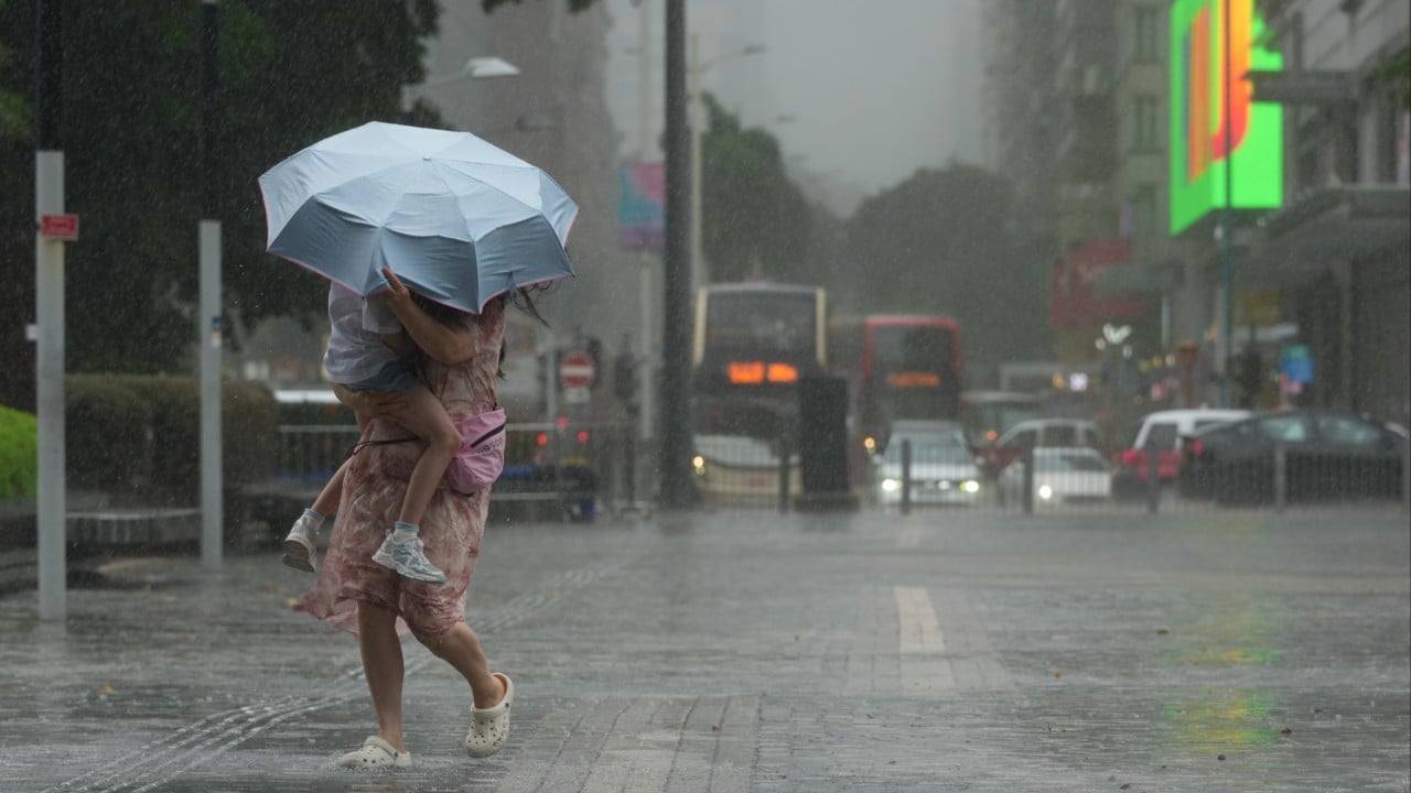
Hong Kong just cancelled the Standby Signal No. 1. You might think it is time to pack away the umbrella and plan a weekend junk trip. Don't do that yet. The Hong Kong Observatory keeps warning us that rough weather is sticking around well into next week. The tropical cyclone is pulling away, but it is leaving behind a messy trail of heavy showers and violent gusts.
Locals know how this goes. A cancelled signal feels like a green light. But the reality on the ground is often much wetter and wilder than a simple tracking map suggests. The interaction between departing storms and seasonal monsoons creates unpredictable conditions across the territory. If you are commuting through Central or living in a exposed coastal spot like Shek O, you need to keep your gear ready.
The illusion of clear skies after a Standby Signal No. 1
The Standby Signal No. 1 means a tropical cyclone is within 800 kilometers of Hong Kong and might affect us. When the Hong Kong Observatory drops the signal, it means the immediate threat from that specific rotating system has faded. The storm has either made landfall somewhere in Guangdong or tracked far enough across the South China Sea to reduce its direct impact on local winds.
That sounds like good news. But it triggers a false sense of security.
Tropical cyclones are massive atmospheric engines. They don't just vanish cleanly off the map. As they move away, they drag vast bands of moisture right behind them. In the summer months, these systems frequently pull the southwest monsoon right into the South China Sea. The result is a prolonged period of instability that outlasts the storm itself.
You get sudden, intense downpours. The sky looks perfectly fine one minute, then opens up the next. Wind gusts can still match the strength of a T3 signal, especially in high offshore areas or between the skyscraper canyons of Kowloon. Dropping the T1 signal simply means the cyclone itself is no longer the primary driver of our weather. The active weather pattern it left behind is still very much in control.
Why the southwest monsoon is the real enemy this week
The Hong Kong Observatory specifically highlighted that an active southwest monsoon is taking over. This atmospheric setup is notorious for dumping massive amounts of rain on the southern coast of China.
Think of the monsoon as a conveyor belt. It carries hot, saturated air straight from the Indian Ocean and the tropical parts of the South China Sea. When this wet air mass hits the rugged terrain of Hong Kong, it rises rapidly. That triggers convective thunderstorms. These storms are localized, violent, and incredibly hard to predict with perfect accuracy.
The geography of Hong Kong worsens the situation. The hills of Lantau Island and the New Territories force the incoming monsoon winds upward. This creates localized downpours that can trigger flash flooding in low-lying areas while parts of Hong Kong Island stay relatively dry. You might check the radar app and see nothing, only to get drenched twenty minutes later.
The wind shifts are another problem. Monsoon winds tend to blow consistently from the south or southwest. This means areas that were sheltered from the tropical cyclone might suddenly face the full force of the gale. Coastal communities facing south need to stay alert. The waves will remain choppy, and sea swells will persist even without an active typhoon signal.
What to expect from the Hong Kong Observatory forecast
The official nine-day forecast paints a damp picture. We are looking at daily showers and persistent thunderstorms extending well into the middle of next week.
Temperatures will stay high, hovering around 32 degrees Celsius during the brief sunny intervals. The humidity will be intense. That combination of heat and moisture fuels the instability, meaning afternoon thunderstorms will be a regular feature of your weekly commute.
The wind speeds will fluctuate. The forecast indicates force four to five winds, occasionally hitting force six on high ground and offshore islands. On the Beaufort scale, force six means strong winds capable of making umbrellas difficult to use. It creates large waves at sea. Fisherman and water sports enthusiasts should stay out of the water.
The threat of sudden rainstorms means the Amber or Red Rainstorm Warning Signals are highly possible over the coming days. The Landslip Warning might also come into play if the soil on our steep hillsides becomes completely saturated by consecutive days of rain.
How to prep your apartment and commute for unpredictable downpours
You need a strategy to deal with this extended stretch of wet weather. Living in Hong Kong during a monsoon setup requires practical adjustments to your daily routine.
First, check your windows. The wind direction has shifted to the southwest. If your flat faces south or west, inspect the rubber seals on your window frames. The constant pressure from monsoon winds can force rainwater through tiny gaps, ruining your flooring or drywall. Clear out the drainage channels on your balcony to prevent pooling water from leaking inside.
Second, rethink your footwear. The marble floors in Hong Kong malls and MTR stations become incredibly slick when everyone drags in rainwater. Wear shoes with deep rubber treads. Avoid smooth-soled leather shoes or flimsy flip-flops that offer zero traction on wet tiles.
Third, adapt your travel plans. Flash floods can slow down traffic on major arteries like the Island Eastern Corridor or the Lung Cheung Road. The MTR is your safest bet during heavy downpours, but stations get incredibly crowded as people seek shelter. Give yourself an extra fifteen minutes to get to work or appointments.
Fourth, manage your laundry. The high humidity means clothes will take forever to air dry on a balcony. Use a dehumidifier in a closed room to dry your clothes quickly. Leaving damp clothes out in this weather leads to mold growth and that distinct, musty odor that is impossible to wash out.
Simple steps to stay safe when the weather turns unpredictable
Keep a high-quality, sturdy umbrella in your bag at all times. Lightweight pocket umbrellas usually collapse the moment a force six gust hits a street corner in Central. A windproof umbrella with fiberglass ribs is worth the extra weight.
Download the Hong Kong Observatory mobile app and turn on push notifications for rainstorm warnings. The weather changes incredibly fast during an active monsoon. Checking the forecast before you leave the house in the morning is not enough. You need real-time radar updates.
Avoid hiking or visiting country parks. The soil on hiking trails across Hong Kong Island and the New Territories is already loose from recent rains. Heavy showers can trigger sudden landslides or rockfalls without warning. Stream trekking is exceptionally dangerous right now because flash floods can rush down mountain gullies in a matter of seconds.
Stay away from the shoreline. Areas like the Tsim Sha Tsui promenade, Kennedy Town, and Sai Kung will experience sudden swells. People love taking photos of big waves, but a single rogue wave can easily sweep you off a pier.
Keep an eye on the Special Announcement on Flooding in the Northern New Territories if you live or travel near places like Sheung Shui or Yuen Long. Low-lying farmland and village roads in these districts flood rapidly when the drainage systems get overwhelmed.
The cancelled T1 signal is just a change in the meteorological classification. The actual weather outside your window remains unstable, wet, and potentially hazardous. Pack your rain gear, check the radar updates frequently, and stay away from the coast until this active monsoon pattern finally clears out late next week.