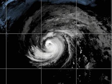
Hurricane Fausto just picked up serious heat in the Pacific, churning into a Category 2 storm with sustained winds around 100 mph.
Right now, it's sitting about 1,300 miles west of Mexico's Baja California peninsula and roughly 1,600 miles east of Hilo, Hawaii. If you've been watching the weather satellite maps this week, you know this system started off relatively quiet before organizing fast over open waters. The National Hurricane Center in Miami confirms the storm is heading westward, setting its sight on the Hawaiian Islands for sometime next week.
It's still too early to pinpoint an exact landfall spot or predict total rainfall inches. Weather models always shift when storms travel across thousands of miles of ocean. But the trajectory is clear enough to warrant immediate attention.
What the Pacific Ocean Is Doing Right Now
Ocean storms don't exist in a vacuum. While Fausto powers up out in the open Pacific, its energy is already reaching the West Coast. Big ocean swells generated by the storm's 100 mph wind core are pushing long-period waves toward Southern California and Baja California.
If you're heading to beaches in San Diego, Orange County, or Los Angeles, ocean conditions are dangerous. Lifeguards are issuing warnings for life-threatening rip tides and heavy surf. You don't need a direct hit from a hurricane to feel its teeth.
Farther east, Tropical Storm Bertha recently dumped rain on Texas and Louisiana before dissolving on Thursday. With Bertha gone, forecasters at the National Hurricane Center are focusing almost entirely on Fausto's path toward Hawaii.
Why Pacific Hurricanes Hit Hawaii Differently
Hawaii gets ocean storms fairly often, but full-scale direct hits from major hurricanes remain unusual. Cool water ocean currents surrounding the islands usually act like a natural shield, weakening storms as they approach from the east.
That shield isn't invincible. Warm sea-surface temperatures can keep a storm like Fausto intact longer than expected.
When a storm approaches from the east-southeast, Hilo and the Big Island's windward side usually take the first ocean swells. The high mountains of Mauna Kea and Mauna Loa tend to disrupt wind patterns, but they also trigger intense rain bands. That means flash flooding and landslides can become major threats even if the storm's center stays miles offshore.
Maui County and Oahu face their own risks. High winds can disrupt power grids instantly, and island electrical systems take longer to repair when supply chains rely on shipping vessels.
Preparing Without Panic
Don't wait until official warnings upgrade to supply rushes. The best time to prepare for an approaching Pacific hurricane is while it's still 1,600 miles out.
Start with basic water and food inventory. Every home needs at least two weeks of non-perishable food and one gallon of clean water per person per day. If power lines drop, municipal water treatment systems can stall or suffer pressure drops.
Check your backup power sources. Charge up extra battery banks for phones and handheld radios right away. If you rely on generators, test them outside to verify they work and keep fuel stored safely away from living areas.
Secure loose items around your yard. Outdoor furniture, potted plants, and loose roofing material turn into dangerous flying debris once winds top 40 or 50 mph.
Keep an eye on official updates directly from the National Weather Service in Honolulu and the National Hurricane Center. Track the daily forecast advisories rather than single social media posts, since atmospheric steering currents will determine Fausto's final path over the coming days.