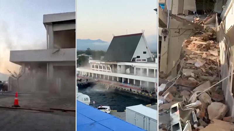
A powerful magnitude 7.7 earthquake struck off the coast of Indonesia's Flores region, shaking the island of Flores and triggering brief tsunami warnings that sent thousands fleeing to higher ground. The shallow offshore tremor, originating at a depth of roughly 10 to 15 kilometers near Mbay in the Nagekeo district, caused widespread panic, cracked buildings, and collapsed port structures while forcing emergency hospital evacuations in East Nusa Tenggara. Though initial alerts were subsequently lifted after monitoring confirmed only minor sea-level changes, the incident highlights the persistent vulnerabilities of communities sitting along the planet's most volatile seismic corridors.
Anatomy of a Shallow Subduction Threat
Seismological data from the United States Geological Survey and Indonesia's Meteorology, Climatology, and Geophysics Agency pinpoints the danger not just in the numerical magnitude, but in the focal depth. When a 7.7-magnitude rupture occurs at a shallow depth of just over 10 kilometers beneath the seabed, the energy absorption of the Earth's crust is minimal. The shockwaves arrive at the surface with maximum destructive velocity.
For the half a million residents exposed to very strong to severe shaking across Flores and neighboring islands, the morning jolt offered no preliminary warning. Witnesses reported a violent, wrenching motion that lasted for roughly a minute. This specific fault zone in the Flores Sea acts as an active collision boundary where major tectonic plates grind against one another, constantly accumulating stress that discharges violently when frictional thresholds are breached.
The Human Toll and Infrastructure Reality
Early reports from regional authorities confirmed multiple fatalities and injuries, primarily caused by collapsing masonry and falling debris as residents scrambled from homes, markets, and places of worship. At St. Peter Major Seminary on Flores, students and faculty fled an assembly hall as its roof gave way, while local hospitals were forced to establish makeshift outdoor triage units. Patients requiring continuous monitoring were moved into courtyards alongside IV stands and oxygen tanks.
Port infrastructure fared poorly as well. The waiting room at the port terminal in Maumere suffered structural collapse, emphasizing a structural engineering deficit that plagues many regional maritime hubs. While major urban centers on Java possess stricter building code enforcement, remote islands in East Nusa Tenggara often rely on non-engineered masonry that offers zero resistance to lateral seismic loads.
Tsunami Preparedness Under Pressure
The immediate issuance of a Level II tsunami warning by national agencies triggered rapid self-evacuation protocols. Residents in low-lying coastal zones moved inland or climbed more than ten meters up adjacent hillsides, heeding lessons hard-earned from historical disasters in the archipelago. Tidal gauges subsequently recorded minor surges—reaching up to roughly one meter in Ende—before authorities gave the all-clear and lifted the advisories.
This rapid retraction prevented prolonged economic paralysis, yet the frantic hours following the primary tremor exposed communication bottlenecks. Rural communities relying on local sirens and word-of-mouth evacuation face distinct hurdles compared to hyper-connected metropolitan populations. As aftershocks continued to rattle the Flores Sea, the event served as a stark operational test for provincial disaster mitigation agencies, underscoring that infrastructure hardening and real-time community response mechanisms remain a work in progress across eastern Indonesia
7.7 magnitude quake strikes Indonesia, tsunami warning issued
This video provides real-time news coverage and visual context regarding the 7.7-magnitude earthquake that struck off the coast of Indonesia.