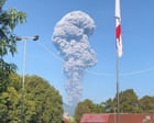
The death of three hikers on the slopes of Mount Dukono in North Maluku is not a tragedy of bad luck. It is a failure of system and perception. When one of Indonesia’s most active volcanoes claimed these lives during a sudden intensification of ash and gas, the official narrative immediately pivoted to "unpredictable nature." This is a convenient shield for authorities and tour operators. The reality is that Dukono has been in a near-constant state of eruption since 1933. It is a persistent threat that has been rebranded as a tourist attraction, masking the lethal volatility of a stratovolcano that does not follow a script.
Mount Dukono sits on the remote northern edge of Halmahera island. It is not a single peak but a complex of craters. For decades, it has belched ash plumes that stretch thousands of meters into the sky, often disrupting local aviation and coating the town of Tobelo in grey grit. Because this activity is so frequent, it has become background noise. Locals and visitors alike have fallen into a trap of normalcy bias. They see the smoke, they hear the rumbles, and because nothing catastrophic happened yesterday, they assume nothing will happen today. This time, the mountain changed its rhythm.
The Geography of Risk
To understand why these hikers died, you have to look at the physical layout of the Malupang Warirang crater. Unlike volcanoes with long periods of dormancy, Dukono is an open-vent system. This means it is constantly degassing. While this can sometimes prevent the massive pressure buildup seen in "plugged" volcanoes like Mount St. Helens, it creates a false sense of security. Hikers often feel emboldened to approach the crater rim because the "eruption" looks the same as it did three hours ago.
The three victims were caught in a localized pyroclastic surge—a fast-moving current of hot gas and volcanic matter. While the broader eruption might appear stable from a distance, the internal dynamics of the crater are chaotic. A minor collapse of the interior crater wall or a shift in wind direction can instantly turn a "safe" viewing point into a kill zone. In this instance, the hikers were reportedly near the summit when a sudden burst of high-temperature ash overwhelmed them. They had nowhere to run. The terrain at the summit is composed of loose scoria and slippery ash. Speed is impossible.
The Tourism Industrial Complex
Indonesia’s "Ring of Fire" is a goldmine for the Ministry of Tourism. From Bromo to Ijen, volcanic tourism brings in millions of dollars and sustains entire village economies. However, the infrastructure for safety rarely keeps pace with the marketing. At Dukono, the "forbidden zone" is often a suggestion rather than a strictly enforced perimeter.
Local guides, many of whom lack formal volcanology training, rely on ancestral knowledge and visual cues. This is valuable but insufficient when dealing with a complex volcanic system. There is a recurring tension between the Center for Volcanology and Geological Hazard Mitigation (PVMBG) and the local trekking industry. The PVMBG sets alert levels and exclusion zones—usually a three-kilometer radius for Dukono—but enforcement is handled by local agencies with limited personnel and a vested interest in keeping the trails open.
When a hiker pays for a guided ascent, they are buying the expertise of the guide. If that guide is willing to bypass a "Level II" alert status to provide a better view, the hiker assumes the risk is manageable. It isn't. The volcanologists in Bandung are looking at seismic data, tiltmeters, and gas compositions. The hiker is looking at a beautiful photo for their social media feed. These two worlds crashed together on the slopes of Halupang Warirang.
The Problem with Alert Levels
The Indonesian volcanic alert system operates on four levels.
- Level I (Normal): No significant activity.
- Level II (Waspada/Alert): Increased activity; restricted zones are established.
- Level III (Siaga/Standby): Significant escalation; imminent threat.
- Level IV (Awas/Danger): Eruption is occurring or certain.
Dukono has lived at Level II for years. This is the danger of "permanent" alerts. When a mountain is always on alert, the word loses its meaning. It becomes a bureaucratic baseline rather than a warning. The hikers who died were technically inside a restricted zone, but so were hundreds of others who climbed the mountain in the weeks prior. When the rule is broken every day without consequence, the rule effectively ceases to exist.
The Physiological Toll of Volcanic Gas
We often focus on the heat or the lava, but the silent killer at Dukono is the gas. The complex emits high concentrations of sulfur dioxide ($SO_2$) and hydrogen sulfide ($H_2S$). Even without a full-scale eruption, these gases can pool in depressions on the mountain.
In a high-stress situation—like a sudden increase in ash output—hikers begin to breathe more deeply. If they inhale a concentrated pocket of $SO_2$, the gas reacts with the moisture in their lungs to form sulfuric acid. This leads to immediate respiratory distress, pulmonary edema, and incapacitation. You don't have to be touched by fire to die on a volcano. You just have to lose your ability to breathe for ninety seconds.
The recovery of the bodies was delayed by these very conditions. Rescuers had to wait for the wind to clear the toxic plume before they could reach the site. This highlights the grim reality of volcanic SAR (Search and Rescue) operations: the environment remains lethal long after the initial event.
The Myth of the Controlled Environment
Modern travel has sold us the lie that the world is a curated museum. We expect handrails on the edge of the abyss. But Dukono is a raw, geologic engine. There are no handrails. There are no sensors every ten meters.
The investigative reality is that the monitoring equipment at Dukono is often hampered by the very environment it tries to measure. Ash is corrosive. Lightning strikes at the summit frequently fry sensitive electronics. There are gaps in the data. When the PVMBG issues a warning, it is often based on the best available information, which might be minutes or hours out of date.
Furthermore, the communication chain from the monitoring station to the trailhead is brittle. It relies on a series of hand-offs between government officials, local police, and village leaders. In the time it takes for a warning to trickle down, a hiker can already be at the rim.
A Failure of Responsibility
The three deaths at Dukono are being framed as a tragedy of "reckless" hikers. While it is true they entered a restricted area, focusing solely on individual choice ignores the systemic failures that allowed them to be there.
If a zone is truly restricted, it must be physically barred or strictly patrolled. If a volcano is in a state of permanent eruption, the tourism model must shift from "access at your own risk" to "strictly regulated scientific viewing." Instead, we see a laissez-faire approach where the government collects the fees and then blames the victims when the mountain does exactly what it has been doing for ninety years.
We must stop treating these events as "freak accidents." They are the logical conclusion of a system that prioritizes tourism revenue over geomorphological reality. As long as the exclusion zones around Dukono remain porous and the alert levels remain static, more bodies will be recovered from the ash.
The mountain did not "act out." It merely continued its process. The fault lies with the humans who convinced themselves they could stand in the path of that process and walk away unscathed. Survival on a volcano isn't about bravery or gear. It's about respecting the math of the exclusion zone.
Stay off the crater rim.