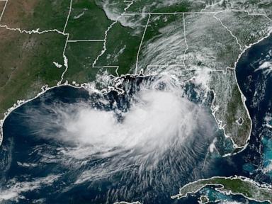
When a tropical storm starts losing its punch off the coast, people tend to let their guard down. You see the headlines saying a system is weakening, and the collective sigh of relief is almost audible. That reaction is completely natural. It's also dangerous. Tropical Storm Bertha provided a classic look at why a degrading tropical system off the Gulf coast still demands serious attention.
downgraded storm isn't a dead storm. Weather systems churning through coastal regions bring heavy rainfall, flash flooding, and unexpected storm surges long after their peak wind speeds drop. If you live near the coast or follow severe weather patterns, understanding what actually happens during this weakening phase is crucial.
The Reality of Weakening Tropical Systems
Wind speed gets all the attention. The Saffir-Simpson Hurricane Wind Scale conditions how we think about storms, pushing us to focus almost entirely on sustained wind numbers. When Bertha's maximum sustained winds began to drop off the Gulf coast, it officially signaled a reduction in category strength. But wind is only a fraction of the threat.
Water causes the vast majority of tropical storm damage and fatalities. As a storm like Bertha slows down and weakens structurally, its wind field often expands. The energy doesn't just vanish into thin air. Instead of a tight, intense core of destructive wind, you end up with a massive, sprawling envelope of moisture pushing tropical air far inland.
National Oceanic and Atmospheric Administration rain totals routinely show that slow-moving, degrading storms drop significantly more rain than fast-moving Category 3 hurricanes. The storm sits over warm waters, pulling up vapor and dumping it directly onto saturated coastal soil.
Why the Gulf Coast Is Especially Vulnerable
The geography of the Gulf coast creates a unique setup for tropical systems. The shallow continental shelf in the Gulf of Mexico allows even weak wind profiles to push significant amounts of seawater toward the shoreline.
You don't need hurricane-force winds to trigger coastal flooding. A sustained 40 mph tropical storm wind blowing from the south or southeast over several high tide cycles will pile water up into bays, bayous, and coastal rivers.
- Shallow bayous and slow drainage: Coastal waterways are already at or near sea level. Added rain has nowhere to go.
- Saturated ground conditions: Prior atmospheric rain events mean the ground acts like a full sponge.
- Tidal interactions: High tides block river runoff from pushing out to sea, backing up water into residential areas.
During Bertha's lifecycle, atmospheric conditions like wind shear and cooler water upwelling near the coast acted as a brake on the storm's intensity. Atmospheric wind shear basically tilts the storm, disrupting the tight chimney effect needed to keep a tropical system organized. Dry air gets sucked into the core. The storm chokes. Yet, while the core collapses, the outer rainbands remain heavily loaded with tropical moisture.
Common Misconceptions About Storm Warnings
People make predictable mistakes when tropical warnings get downgraded. I've seen it repeatedly in coastal communities. A tropical storm watch gets dropped, or an advisory mentions "weakening," and residents instantly cancel their preparation plans.
The National Hurricane Center explicitly warns against this framing, but public perception lags behind the meteorology. A weakening storm carries distinct hazards that catch people off guard.
Flash Flooding Over Inland Areas
The danger shifts location as the storm degrades. The immediate coastline might avoid structural wind damage, but inland areas dozens or even hundreds of miles away suddenly face life-threatening flash floods. Train-tracking rainbands—where heavy storms move continuously over the exact same path—can dump 10 to 15 inches of rain over a single afternoon.
Isolated Tornado Risks
Right-front quadrants of weakening tropical storms remain breeding grounds for quick-hitting tornadoes. These tornadoes are often low-topped, meaning they don't show up as dramatically on standard weather radar until they are almost on top of you. They hit with very little warning compared to midwestern supercells.
How to Prepare for a Weakening Coastal Threat
Don't let the word "weakening" fool you into dropping your basic safety protocols. The response to a degrading tropical storm requires a distinct focus on water rather than structural wind protection.
First, clear storm drains and gutters around your home immediately. Leaves and debris block local drainage networks, turning an otherwise manageable three inches of rain into a flooded garage.
Second, check your local river forecasts through the National Weather Service. Don't just look at the current weather outside your window. Look at the hydrograph forecasts for the rivers upstream from your town. Water flows downhill, and crests can hit 24 to 48 hours after the rain stops falling.
Third, keep your vehicle parked on high ground and avoid driving through standing water. It takes less than 12 inches of moving water to float most standard passenger vehicles.
Pay close attention to local emergency management updates rather than relying solely on national headlines about a storm's peak wind numbers. Track local rainfall projections, stay aware of active flash flood watches, and keep your emergency supplies accessible until the entire weather system moves out of your region.